By Ana Verayo, | March 29, 2016
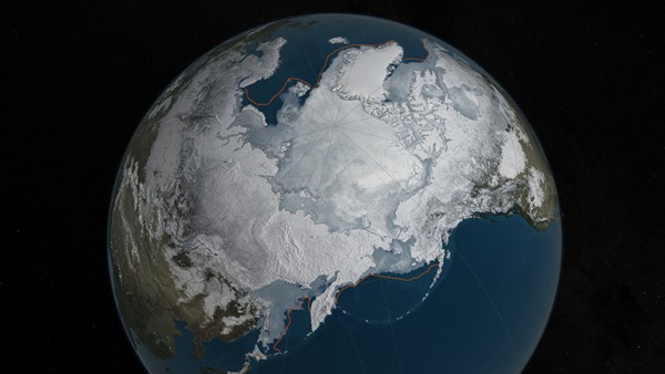
Arctic sea ice is at a record low wintertime maximum extent for the second straight year. (NASA Goddard's Scientific Visualization Studio/C. Starr)
The ice covering the northern polar region or the Arctic is now reaching its record lowest of this year, which can impact the weather of the planet, according to NASA scientists.
March is when Arctic's sea ice reaches its maximum cover in both area and thickness before it recedes in a yearly minimum by September. According to NASA scientist, Walt Meier, this winter has been extremely warm where temperatures were 10 to 15 degrees hotter than normal in the Arctic. NASA scientists reveal that this year's Arctic sea ice extent or its maximum area and volume is the lowest ever recorded in 40 years.
Like Us on Facebook
The space agency has been collecting data on Arctic sea ice extent since the late 1970s where last year's maximum was the fourth lowest on record and this year's the lowest ever. Every year, the Arctic region's sea ice extent is varied but scientists have been noticing a downward spiral trend, making climate scientists worry about the changing climate of Earth.
Meier says that the ice lost during this year's wintertime was similar to the size of two Texases and in the summer, this ice loss can be even more extreme were double of that area have been already lost in terms of area coverage.
Apart from this, ice in the region is now becoming thinner compared to past years, where 50 percent of the original volume of ice has been lost or the mass of sea ice, ever since record keeping began, Meier adds.
These effects are also not only limited to the Arctic. Ice plays an important role in keeping off heat, as it reflects more than 80 percent of the sun's rays back into space. With lesser ice cover, the sun's rays gets directly absorbed by the world's oceans which warms the water at an alarming rate.
Meier explains that when water warms up, the contrast in the lower latitudes of the globe also changes significantly. This contrast is essential in maintaining the jet stream and storm tracks including general weather patterns. When the Arctic warms, the weather patterns in the lower latitudes will also become affected.
For example, cold air stays in the Arctic region due to polar vortex winds that travels in a circular direction, counterclockwise. However, when sea ice extent lessens, the Arctic gets warmer where high pressures are formed and this polar vortex weakens, which allows cold air to flow southbound, causing more frigid winters.
NASA also recently launched two missions to investigate further this phenomenon, known as Arctic: Operation IceBridge and Oceans Melting Greenland which is also known as OMG. Scientists will conduct and expedition to the Arctic and Greenland via land and air where they will obtain measurements of the region's sea ice and glacier thickness.


-
Use of Coronavirus Pandemic Drones Raises Privacy Concerns: Drones Spread Fear, Local Officials Say

-
Coronavirus Hampers The Delivery Of Lockheed Martin F-35 Stealth Fighters For 2020

-
Instagram Speeds Up Plans to Add Account Memorialization Feature Due to COVID-19 Deaths

-
NASA: Perseverance Plans to Bring 'Mars Rock' to Earth in 2031

-
600 Dead And 3,000 In The Hospital as Iranians Believed Drinking High-Concentrations of Alcohol Can Cure The Coronavirus

-
600 Dead And 3,000 In The Hospital as Iranians Believed Drinking High-Concentrations of Alcohol Can Cure The Coronavirus
-
COVID-19: Doctors, Nurses Use Virtual Reality to Learn New Skills in Treating Coronavirus Patients
