By Ana Verayo, | February 22, 2016
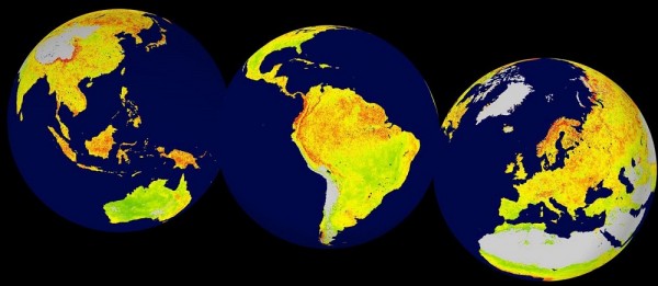
Global map of the Vegetation Sensitivity Index (VSI), a new indicator of vegetation sensitivity to climate variability using satellite data.
Climate change can be felt as the rise of global temperatures impact different regions of the planet, which can result in various effects depending on the region. Scientists now reveal which regions on Earth are the most sensitive to this changing climate with this new map.
Like Us on Facebook
Climate scientists are already aware about the continuous warming of the planet leading to rising temperatures, where some parts of Earth can be more sensitive to these climate temperature changes than other regions.
In this new study, scientists were able to identify when an ecosystem becomes sensitive because of these changes, and determine which factors can indicate this sensitivity across the various regions of the globe for more comparison.
A team of researchers from the University of Bergen, Norway developed this new metric in order to obtain measurements of climate sensitivity in various ecosystems. This metric is known as the Vegetation Sensitivity Index that maps out how a specific region on the planet can be affected by warming temperatures.
Using satellite data that was consolidated from 2000 to 2013, scientists analyzed plants and overall vegetation on a global scale. The new map identifies what are the driving factors for vegetation production based on monthly timescales, allowing computations that resulted in the sensitivity index.
This crucial satellite data that was collected for a period of 14 years revealed key climate variables such as air temperature, water availability and cloud cover. Using these variables, the index compares these to the vegetation productivity during changing climate temperatures on a global scale.
According to lead author of the study, biologist Alistair Seddon from the University of Bergen, based on this satellite data that was collected, we can now identify the areas that are showing high sensitivity to climate variability from the past 14 years.
The new map reveals that the most sensitive ecological regions to climate change are the alpine regions around the world, tropical rainforests, some parts of the boreal forest belt and some regions of the Arctic tundra. Apart from forests, prairies, steppes and other parts of North and South America including Central Asia and east Australian forests are also susceptible to these changes in climate.
With this new method, ecosystems can now be assessed and reveal more data about how these parts can be affected by short and long term rise in temperatures. In this new map, researchers can now show which sensitive regions and ecosystems would respond to climate change.
This new study is published in the journal Nature.


-
Use of Coronavirus Pandemic Drones Raises Privacy Concerns: Drones Spread Fear, Local Officials Say

-
Coronavirus Hampers The Delivery Of Lockheed Martin F-35 Stealth Fighters For 2020

-
Instagram Speeds Up Plans to Add Account Memorialization Feature Due to COVID-19 Deaths

-
NASA: Perseverance Plans to Bring 'Mars Rock' to Earth in 2031

-
600 Dead And 3,000 In The Hospital as Iranians Believed Drinking High-Concentrations of Alcohol Can Cure The Coronavirus

-
600 Dead And 3,000 In The Hospital as Iranians Believed Drinking High-Concentrations of Alcohol Can Cure The Coronavirus
-
COVID-19: Doctors, Nurses Use Virtual Reality to Learn New Skills in Treating Coronavirus Patients
