By Ana Verayo, | February 17, 2016
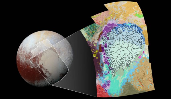
This map of the left side of Pluto’s heart-shaped feature uses colors to represent Pluto’s varied terrains, which helps scientists understand the complex geological processes at work.
NASA's New Horizons spacecraft revealed many of the surprising geological wonders in Pluto and now, as scientists are trying to understand the complex geology on the dwarf planet, as mission scientists constructed new geologic maps of its surface showing how Pluto has evolved over time.
Like Us on Facebook
This new map spans Pluto's surface area measuring 1,290 miles from north to south, including the expanse of nitrogen filled ice plains known as Sputnik Planum along with its surrounding terrain. The maps are overlaid with colors representing various geological features where each region or terrain is identified by its own texture and morphology, if it is smooth, craggy or rugged.
The resolution of the images also determine the morphology of each terrrain, for example, if one terrain unit on this map is imaged at 1,050 feet per pixel or more, then scientists can map out the units with more accuracy.
The many blue and green colored units that cover the center of the map represent different textures that can be observed along the Sputnik Planum, beginning from its cellular terrain found in the center and northern parts, to the smoother plains and those that are pockmarked with pits down to the south. The black borders determine the boundaries of the changing regions that also represent troughs of cellular regions that are filled with nitrogen ice.
The purple regions represents chaotic mountain ranges between the Sputnik's west border and the pink units are identified as scattered, floating hills on the eastern edge. A cryovolcanic feature or a possible ice volcano known as Wright Mons is mapped out in red at the southern corner of this map as well where the rugged highlands of the Cthulhu Regio are indicated in dark brown along the western borders that are also filled with numerous impact craters that are colored yellow.
With this new color coded map of Pluto, mission scientists can now determine which units overlap which borders of diverse terrains, to build a chronological timeline for the evolution of each terrain unit. This can be demonstrated as the yellow craters that are on the western part of the map that were probably formed after the terrain surrounding them.
This new map can offer crucial clues about how Pluto's geological processes work and how these processes interact with each other to produce different terrains.
The basis for this new map is a composite image from a mosaic of 12 images that are captured by New Horizons' Long Range Reconnaissance Imager (LORRI), with a resolution of 1,280 feet per pixel. The images were taken from a distance of 48,000 miles above Pluto, before an hour and 40 minutes into the closest approach of the New Horizons spacecraft last July 14.


-
Use of Coronavirus Pandemic Drones Raises Privacy Concerns: Drones Spread Fear, Local Officials Say

-
Coronavirus Hampers The Delivery Of Lockheed Martin F-35 Stealth Fighters For 2020

-
Instagram Speeds Up Plans to Add Account Memorialization Feature Due to COVID-19 Deaths

-
NASA: Perseverance Plans to Bring 'Mars Rock' to Earth in 2031

-
600 Dead And 3,000 In The Hospital as Iranians Believed Drinking High-Concentrations of Alcohol Can Cure The Coronavirus

-
600 Dead And 3,000 In The Hospital as Iranians Believed Drinking High-Concentrations of Alcohol Can Cure The Coronavirus
-
COVID-19: Doctors, Nurses Use Virtual Reality to Learn New Skills in Treating Coronavirus Patients
