By Ana Verayo, | February 01, 2016
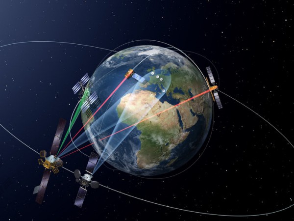
The European Data Relay System (EDRS) is designed to transmit data between low earth orbiting satellites and the EDRS payloads in geostationary orbit using innovative laser communication technology
Europe just launched a a satellite to begin a "data superhighway" that is located in lower Earth orbit which is known as the European Data Relay System (EDRS) by the European Space Agency. A telecommunications satellite was launched from the Baikonur Cosmodrome in Kazakhstan on Saturday early morning which was released from a Proton rocket nine hours later.
Like Us on Facebook
When the network is completed, a successful connection can transmit data at speeds of 1.8 gigabytes.
Using a laser, the satellite can collect images of the planet taken by other spacecraft which can transmit them to ground based control centers and observatories. This is crucial for monitoring natural disasters like flooding and earthquakes, to reach places faster that need the most emergency responses than ever before.
To date, current data transfers by Earth observation satellites can take hours to transmit data back on the surface of the planet. The reason for this slow connection is that spacecraft can only send images when they pass a receiving dish which is only 10 minutes worth of visibility for this antenna, during a 90 minute orbit around Earth.
The main goal of the European Space Agency is to fire up these images via laser to a satellite that is located at a much higher, with a more visible view back to the ground station. Now the space agency already placed two Earth observers with onboard optical transmission equipment to offload their data via this new relay satellite that is now located 36,000 kilometers above the equator.
This new laser data highway can prove to be critical during monitoring of pollution accidents, illegal fishing and piracy across oceans where time can be saved to produce a faster and more effective response.
According to ESA director of telecoms, Magali Vaissiere, important shipping routes that go through the Northern polar regions are met with danger, as thick ice flows can destroy these vessels and even threaten human life. Data that is two days old can be useless and unsafe for these critical events in an environment that is in constant motion.
For example, a test has already proven that this works in almost real time, below 20 minutes of monitoring information from the Brazilian coast to the user's desk, producing a quasi real time Earth observation.
The development of the EDRS has already taken more than 10 years, where the task of making satellites to talk to each other using a laser beam can be enough of a challenge, according to ESA roject manager, Michael Witting. The challenge comes when you need to hit another satellite with a laser beam from a distance of 40,000 kilometers, he adds.
When the EDRS network becomes established, planes and drones can fire up data using an EDRS satellite in cloudless skies. Battery of tests await the EDRS, as the ESA says that the system should be fully operational in summer.


-
Use of Coronavirus Pandemic Drones Raises Privacy Concerns: Drones Spread Fear, Local Officials Say

-
Coronavirus Hampers The Delivery Of Lockheed Martin F-35 Stealth Fighters For 2020

-
Instagram Speeds Up Plans to Add Account Memorialization Feature Due to COVID-19 Deaths

-
NASA: Perseverance Plans to Bring 'Mars Rock' to Earth in 2031

-
600 Dead And 3,000 In The Hospital as Iranians Believed Drinking High-Concentrations of Alcohol Can Cure The Coronavirus

-
600 Dead And 3,000 In The Hospital as Iranians Believed Drinking High-Concentrations of Alcohol Can Cure The Coronavirus
-
COVID-19: Doctors, Nurses Use Virtual Reality to Learn New Skills in Treating Coronavirus Patients
