By Ana Verayo, | January 26, 2016
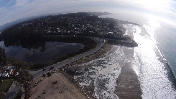
UAV imagery of king tide event at Twin Lakes Beach, Santa Cruz, California.
Locals from California will now be using their smartphones and drones to capture and monitor the coastline's evolving nature.
This January, The Nature Conservancy requests the help of citizens to take photos of flooding and erosion found in coastal areas that are caused by El Nino which is a weather disturbance that is now triggering the wettest winter in California in years.
Like Us on Facebook
Using these crowd sourced images of storm surges and flooding from beaches, these will provide valuable insight for scientists how sea levels could rise due to global warming, giving an idea how the future of climate change will look like in California's coastal regions.
According to chief technology officer Matt Merrifield from The Nature Conservancy, latest drone images can already produce high resolution 3D maps that will prove crucial for scientists as they create models of coastal flooding, for more accurate predictions. He adds that projected models does not look right since there is a lack of evidence, where these photos can back up these models.
Climatologists believe that these coastal storms are fueled by the El Nino phenomenon, where this project can also help raise public awareness. However scientists are also wary that this experiment might not produce the desired result of the organization, but any bit of information is pivotal in getting a clearer idea of the effects of global warming.
If sea levels rise for another 4.6 feet, nearly half a million people in California along with US $100 billion in property and business infrastructures including schools and highways will be at dangerous risk during a storm by 2100, according to a Pacific Institute study in 2009.
According to climatologist William Patzert of NASA's Jet Propulsion Laboratory, California's beaches will become smaller or even disappear completely, due to El Nino caused storms even if it's only temporary. A lot of beach can be lost during a big winter storm surge, and documenting the changing beach landscape can reveal the future in 100 years, he says.
To date, project organizers will not be giving any specific assignments to those who are willing to participate, but specific requests can be carried out as the winter continues, says Merrifield. Merrifield also believes that the project will be successful if users can map real time flooding events that cover 10 to 15 percent of California's coastline, spanning 840 miles.
The team also believes that a curated selection of these 3D maps can show flooding across the entire coast during different dates and times.
The organization is also now working with DroneDeploy that is based in San Francisco, providing a free app for drone owners for consistent coverage. This app will then automatically program flight patterns using cloud based technology in order to manage and make data more feasible, according to developer Ian Smith of the startup company.


-
Use of Coronavirus Pandemic Drones Raises Privacy Concerns: Drones Spread Fear, Local Officials Say

-
Coronavirus Hampers The Delivery Of Lockheed Martin F-35 Stealth Fighters For 2020

-
Instagram Speeds Up Plans to Add Account Memorialization Feature Due to COVID-19 Deaths

-
NASA: Perseverance Plans to Bring 'Mars Rock' to Earth in 2031

-
600 Dead And 3,000 In The Hospital as Iranians Believed Drinking High-Concentrations of Alcohol Can Cure The Coronavirus

-
600 Dead And 3,000 In The Hospital as Iranians Believed Drinking High-Concentrations of Alcohol Can Cure The Coronavirus
-
COVID-19: Doctors, Nurses Use Virtual Reality to Learn New Skills in Treating Coronavirus Patients
