By Kevin Jalain, | February 09, 2017
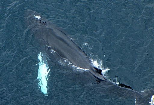
Researchers are now using drones and satellites to track the population of humpback whales. (D. Gordon E. Robertson/CC BY-SA 3.0)
Although they are massive animals, the population of whales are difficult to monitor. Drones have been used to capture footage of whales, and now scientists are turning to even satellites. Researchers in Australia are using satellite imagery to track local humpback whale populations.
According to Live Science, Humpback whales were considered an endangered species under the Endangered Species Act of 1973. However, the U.S. National Marine Fisheries Service lifted the whales' endangered status last year as a result of successful conservation efforts.
Like Us on Facebook
Despite this success, the migratory whales are difficult to track, and many population estimates are largely speculative, according to Curt Jenner, managing director of the Centre for Whale Research in Western Australia.
Sanctuary Ocean Count 2017:
Please support the Hawaiian Islands Humpback Whale National Marine Sanctuary's... https://t.co/8fRC13WNnM— Humpback Whale NMS (@Hihumpbackwhale) January 3, 2017
"People say, 'The whale numbers are very healthy, aren't they?' Well, we can't actually honestly say yes to that, we don't know because we haven't had a monitoring program for this largest humpback population on the planet for about 10 years," Jenner told ABC News of humpbacks in Western Australia. "So we're very interested to find out if this very large number of whales can be sustained and whether it is healthy enough to continue in into the future."
The 2016-2017 Humpback Whale Season Is Underway Hawaii’s tour boats have begun reporting humpback whales... https://t.co/bsflJc3e6d — Humpback Whale NMS (@Hihumpbackwhale) November 3, 2016
The researchers said they would use two satellite images, taken from 373 miles (600 kilometers) above Earth, to conduct a head count of humpback whales as they migrate up the Western Australian coast.


-
Use of Coronavirus Pandemic Drones Raises Privacy Concerns: Drones Spread Fear, Local Officials Say

-
Coronavirus Hampers The Delivery Of Lockheed Martin F-35 Stealth Fighters For 2020

-
Instagram Speeds Up Plans to Add Account Memorialization Feature Due to COVID-19 Deaths

-
NASA: Perseverance Plans to Bring 'Mars Rock' to Earth in 2031

-
600 Dead And 3,000 In The Hospital as Iranians Believed Drinking High-Concentrations of Alcohol Can Cure The Coronavirus

-
600 Dead And 3,000 In The Hospital as Iranians Believed Drinking High-Concentrations of Alcohol Can Cure The Coronavirus
-
COVID-19: Doctors, Nurses Use Virtual Reality to Learn New Skills in Treating Coronavirus Patients
