By Edson Kyle Encina, | January 24, 2017

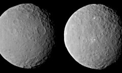
The first batch of images captured by the NOAA's GOES-16 satellite. (NOAA)
The National Oceanic and Atmospheric Administration (NOAA) has shared the first set of awe-inspiring images from its GOES-16 satellite.
The Geostationary Operational Environmental Satellite (GOES) is the very first, next-generation geosynchronous environmental satellite. GOES-16's primary function is to monitor space weather, accurately predict weather and carry out meteorological research.
Like Us on Facebook
It can also be used to take beautiful images of Earth from the vastness of space. These images are so inspirational that NOAA director Stephen Volz compared them to "seeing a newborn baby's first pictures."
Not just an accurate instrument
Volz noted that this satellite is the "most sophisticated technology ever flown in space." The NOAA Satellite and information service director emphasized that the GOES-16 aims to develop "lifesaving forecasts."
We can not argue about the splendor of the images that GOES-16 took. Gizmodo even described the images as a form of art.
Many space pictures do not exactly show the full beauty of Earth from space. Others fail to capture the full, high-definition details of our beloved planet.
This is where the GOES-16 comes in and shatters our expectations by delivering inspiring pictures of the planet we call home.
First of its kind, certainly not the last
According to the NOAA, another satellite is currently being developed. The satellite is said to be undergoing initial tests at Lockheed Martin's Corporation facility in Colorado.
The development team will take about a year to finish the satellite's environmental, mechanical, and electromagnetic testing. The GOES-17 satellite would not be the last.
The GOES-17 will be the second out of four planned environmental spacecraft. Hopefully, we'll get to see more jaw-dropping set of images once the other satellites are fully functional.


-
Use of Coronavirus Pandemic Drones Raises Privacy Concerns: Drones Spread Fear, Local Officials Say

-
Coronavirus Hampers The Delivery Of Lockheed Martin F-35 Stealth Fighters For 2020

-
Instagram Speeds Up Plans to Add Account Memorialization Feature Due to COVID-19 Deaths

-
NASA: Perseverance Plans to Bring 'Mars Rock' to Earth in 2031

-
600 Dead And 3,000 In The Hospital as Iranians Believed Drinking High-Concentrations of Alcohol Can Cure The Coronavirus

-
600 Dead And 3,000 In The Hospital as Iranians Believed Drinking High-Concentrations of Alcohol Can Cure The Coronavirus
-
COVID-19: Doctors, Nurses Use Virtual Reality to Learn New Skills in Treating Coronavirus Patients
