By Ana Verayo, | March 07, 2017
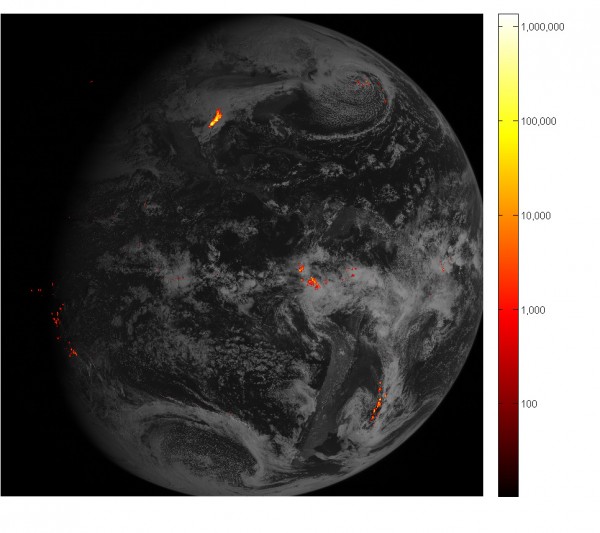
This image shows lightning data captured on February 14, 2017 over the course of an hour and displayed over an image of the Western Hemisphere from the Advanced Baseline Imager on GOES-16. (NOAA/NASA)
One of the most advanced weather satellites in the world has revealed its new data including stunning new images of Earth and the planet's atmosphere. NOAA's (National Oceanic and Atmospheric Administration) GOES-16 weather satellite was launched in November 2016 and is now online to track lightning from space in real-time, transmitting some breathtaking lightning phenomena across the western hemisphere.
Like Us on Facebook
NOAA's GOES-16 weather satellite uses a special, state-of-the-art instrument known as the Geostationary Lightning Mapper that can detect lightning while in geostationary orbit at 23,000 miles above the surface of Earth. It can search for lightning flashes over the entire hemisphere simultaneously. The GLM instrument works by identifying the strength of a storm and predicting stormy or dangerous weather. It identifies severe weather systems when it detects a rapid increased in lightning flashes.
Apart from this, the GLM can also collect data about thunderstorms if they are getting more powerful or even stopping during heavy rainfall. This will also allow weather agencies to predict flash floods.
The GOES-16 weather satellite can also identify areas or regions that are in danger and provide warnings. For example, lightning can strike at dry and hot areas especially in the western United States, causing wildfires during the summer season.
In addition to monitoring and detecting potential lightning strikes over the western hemisphere, the GLM instrument also has other crucial capabilities such as detecting lightning hidden inside cloud formations. Lightning found inside clouds usually brews for several minutes before it releases destructive lightning that can strike on the ground.
Apart from lightning accumulating inside clouds, this weather satellite can also track lightning and thunderstorms across oceans since radar systems on land are too far out to detect these weather disturbances. This data can be helpful in informing weather forecasting agencies who can set warnings for the public, especially for marine and aerial navigation.


-
Use of Coronavirus Pandemic Drones Raises Privacy Concerns: Drones Spread Fear, Local Officials Say

-
Coronavirus Hampers The Delivery Of Lockheed Martin F-35 Stealth Fighters For 2020

-
Instagram Speeds Up Plans to Add Account Memorialization Feature Due to COVID-19 Deaths

-
NASA: Perseverance Plans to Bring 'Mars Rock' to Earth in 2031

-
600 Dead And 3,000 In The Hospital as Iranians Believed Drinking High-Concentrations of Alcohol Can Cure The Coronavirus

-
600 Dead And 3,000 In The Hospital as Iranians Believed Drinking High-Concentrations of Alcohol Can Cure The Coronavirus
-
COVID-19: Doctors, Nurses Use Virtual Reality to Learn New Skills in Treating Coronavirus Patients
